La Reyna
Project Highlights
- Large property covering 106.69 km2
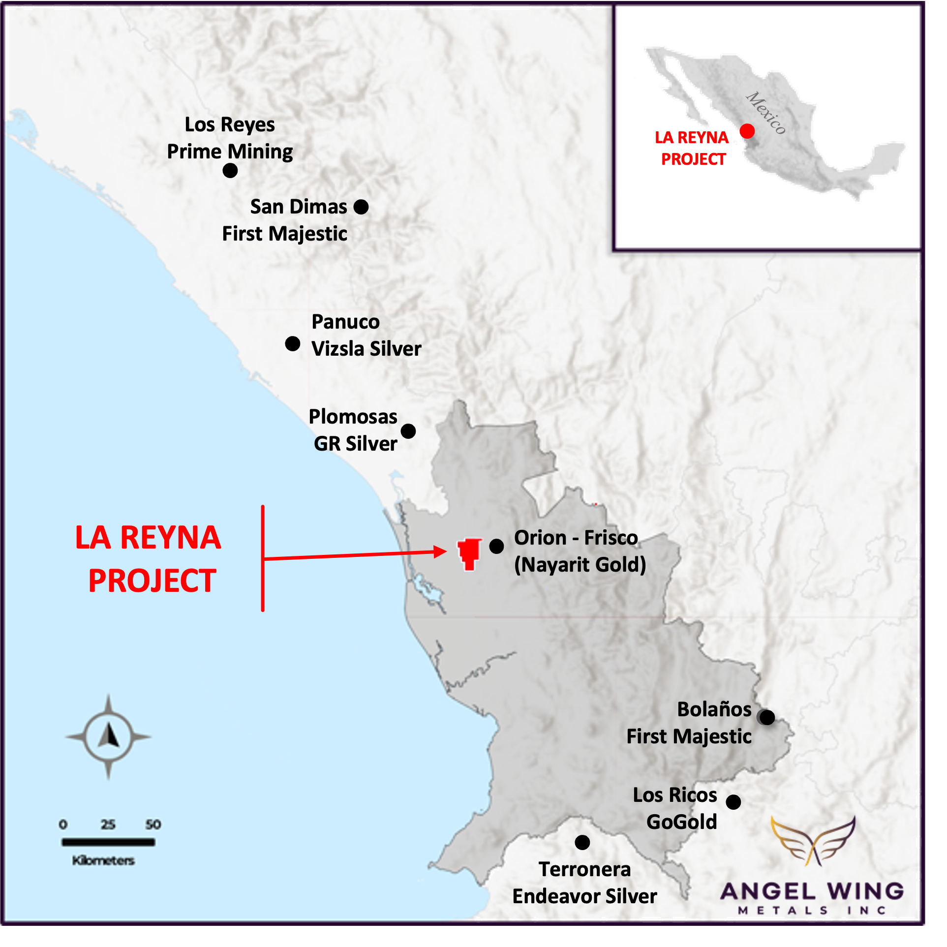
- Located in Nayarit state of Mexico, approx. 250km north of Guadalajara
- Situated on the prolific Sierra Madre Occidental (“SMO”) gold-silver belt
- On trend with major precious metal mines and deposits
- Project is under-explored and undrilled
- Excellent infrastructure: road access, power, rail service, labour, and a nearby port
- Widespread evidence of gold mineralization
- Lack of modern exploration provides a unique opportunity to be the first mover in a potential district-scale gold-silver system
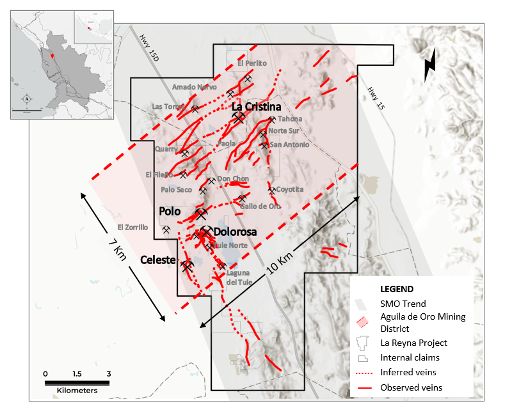
District & Regional Potential
Mexico:
- Mexico has a rich mining history
- Consistently ranks in the world’s top 10 producing countries for gold, silver, and copper. Other important mineral products include lead, zinc, coal, iron, and graphite
- Total value of minerals produced in Mexico in 2018 was $US13.5B(1) including precious, non-precious, and industrial minerals
- Ranked 4th in world for foreign direct investment in mining in 2019 at $US5.47B(2)
Sierra Madre Occidental (SMO) Gold-Silver Belt:
- 900 km long belt from Sonora to Nayarit
- Geology includes a Lower Volcanic Sequence with a very rich endowment of mineral resources
- Hosts numerous large scale precious metals mines, deposits and new discoveries
Geology & Mineralization
Potential for low sulphidation, narrow vein and bulk tonnage gold and silver deposits, along with intrusion hosted porphyry or IOCG mineralization
Favorable SMO Geology with variable vein structural trends; higher gold silver grades frequently occur in the low angle structures
2 areas with probable structural depressions surrounded by altered and mineralized outcrops with bulk tonnage potential; La Presa Basin and Laguna El Tule Basin
Exploration
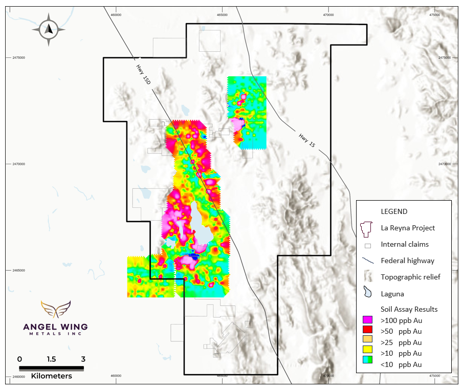
During the 2023 exploration program, regional scale mapping and prospecting covered the Project while areas with vein exposure and gold showings were mapped and sampled in detail. A soil sample program on 100 metre centers covered about 2,100 hectares (1,860 samples) and successfully identified coincident gold and copper soil anomalies for follow up exploration, especially in the El Polo-Dolorosa area, currently the highest priority target for drilling.
Anomalous gold values ranged from a background of 30 ppb Au to a maximum of 3,690 ppb (3.69 g/t Au), with 100 samples returning assays greater than 50 ppb Au, and 46 assays greater than 100 ppb Au.
Soil Assay Contour Map
Gold in parts per billion (ppb) showing sample location grid (black dots) and the El Polo-Dolorosa soil anomaly in pinks and reds.
Target Areas Map
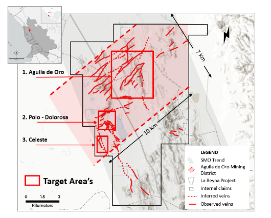
Three Three areas have been identified as the first priority targets to commence drilling:
1. Aguila De Oro
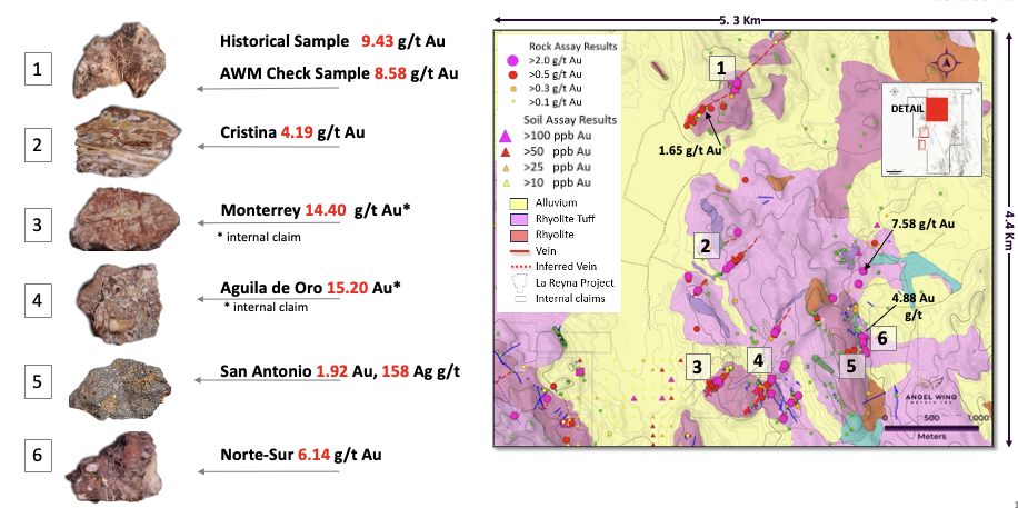
Veins and breccia occur in northeast trending corridors with individual corridors mapped over approximately 500 to 750 metre widths, and open for extension in all directions within a larger 7 by 10 kilometre corridor. Veins vary from 0.15 to 1.8 metres in width, averaging about 1.2 metres, and were traced at surface over a cumulative 10 kilometre strike length. The longest continuous vein exposure measures 1.5 kilometres at surface (the Cristina vein). The untested strike potential of this system of veins is multi-kilometre. Subparallel vein sets provide wide drill targets with near surface bulk mineable potential.
About 1,025 rock samples have been collected along this trend, which is still at an early stage of exploration. Assay results rangefrom nil to 15.2 g/t Au but consistently return 2 – 15 g/t Au in the old workings.
Of these samples:
- Approximately 210 assays were greater than 0.25 g/t Au,
- 134 assays greater than 0.5 g/t Au,
- 75 samples greater than 1.0 g/t Au,
- 40 assays greater than 2.5 g/t Au,
- 14 greater than 5.0 g/t Au. Silver values varied.
19 samples collected from inside old mine workings ranged from 110g/t Ag to 2,938 g/t Ag, including some hand cobbed material.
- 120 samples assayed greater than 10 g/t Ag,
- 55 assays greater than 30 g/t Ag,
- 20 assays greater than 90 g/t Ag.
Lago De Oro Plan Map - showing geology, selected gold assay results and associated rock specimens collected at site
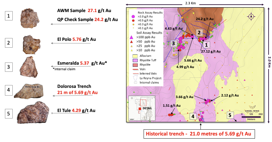
2. El Polo - Dolorosa
This prospect extends at least 2.3 kilometres and varies up to 750 metres wide, and includes numerous other prospects and showings, worked primarily for free gold. Prospects in this area include the past producing El Polo open pit mine and Dolorosa (see Figure 5). No production records are available.
El Polo Open Pit Mine - Shows the extent of the historic operations and selected high grade assay results for gold. The Asterix marks samples collected on an internal third-party claim. Oblique drone view looking northwesterly.
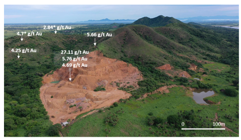
Mineralization at the El Polo pit is structurally controlled by an east westerly trending reverse fault. The fault is a 5 metre thick gold-bearing breccia with a high-grade core (approx. 0.5 m to 2.5 m thick) where a 0.45 m channel sample returned 27.1 g/t Au and 92.0 g/t Ag. Disseminated low grade mineralization occurs across the fault structure and in the surrounding rock estimated to be at least 5 to 8 metres wide. Additional structures are observed in the highwall of the small pit. These could not be systematically sampled due to access issues, but drill holes will be designed to crosscut them.
The El Polo fault crosscuts a northwest structural trend of mineralized veins, breccia’s and disseminated mineralization. This zone can be traced southeasterly over 2.3 kilometre to the Dolorosa prospect, where it is up to 750 m wide. Gold mineralization occurs in veins, breccis and is disseminated in the wall rocks. It is also the location of a strong coincident gold soil anomaly (see Figure 3).
A total of 490 rock samples have been collected from this area. Assay results range from nil to 27.12 g/t Au, with:
- 110 samples returning greater than 0.25 g/t Au,
- 62 samples greater than 0.5 g/t Au,
- 21 samples greater than 2.5 g/t Au,
- 6 samples greater than 5 g/t Au.
Silver assays returned:
- 59 assays with greater than 10 g/t Ag,
- 25 assays with greater than 30 g/t Ag,
- 6 assays with greater than 90 g/t Ag.
The Company’s first drill campaign will begin in this high priority area.
El Polo-Dolorosa Plan Map - showing geology, selected gold assay results and associated rock specimens collected at site
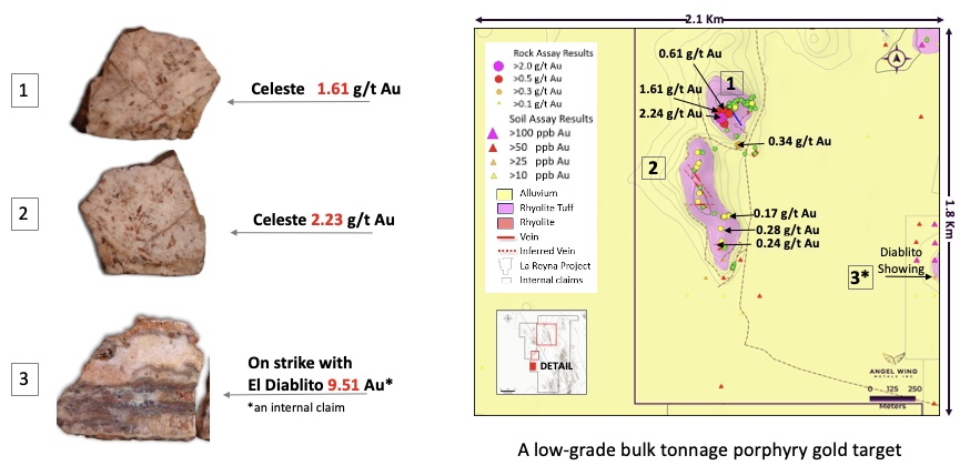
3. Celeste
Celeste is an early-stage exploration target where alteration and mineralization has been mapped over a 1.8 kilometre by 800 metre area that remains open in all directions. The prospect contains zones of intense massive silica alteration crosscut by quartz veins 0.2 to 2 metres in width. Samples from this area returned consistent low grade disseminated gold. Deposits in Mexico with comparable settings to Celeste include the Cerro de Gallo gold porphyry located in Guanajuato State, Mexico (see Argonaut Gold website) or the Tepal gold-copper porphyry deposit in Michoacán State (see Defiance Silver website).
A total of 196 samples were collected here that are almost exclusively anomalous in gold. Assay results range from nil to 2.24 g/t Au.
Samples from this area also returned:
- 50 assays greater than 0.1 g/t Au,
- 25 assays greater than 0.25 g/t Au,
- 14 assays greater than 0.5 g/t Au,
- 6 assays greater that 1.0 g/t Au.
This prospect presents a large bulk tonnage exploration target for gold that requires further mapping, sampling, and geophysics prior to drilling (see Figure 7).
Celeste Plan Map - showing geology, selected gold assay results and associated rock specimens collected at site